A New Adventure Vehicle!
This is my report of... What I did during my summer vacation.
I think that I'm going to call it the Blue Ox.
At Edmark Toyota
I have been looking for a new vehicle for the past year, however over the past 4 years automobile prices have been crazy inflated. And in my region, it seems that most of the dealers do not carry many of the specific model and trim that I wanted.
In July, I noticed that market prices started to normalize.
I created a post within a Facebook Dealer/Client Group that said, "ISO a 2024 4Runner TRD Offroad (not SR5, ORP or Pro) without many additional Dealer or Distributor accessories? I'm located in Texas, but willing to travel for the right vehicle and price."
A guy named Steve Allen contacted me and said that he had such a vehicle. He also mentioned that he and his dealership were located in Boise, Idaho. 😮
For those who know geography, Idaho is a long distance from my home in Texas - about 1,600 miles. However, those who know the outdoors, know that Idaho is an outdoor lover's paradise with beautiful forests, mountains, lakes, rivers and creeks. Some might say that it is an outdoorsman's and fisherman's heaven. Count me in!
Steve and I chatted via Facebook and over the phone, and we struck a deal. The vehicle was the right model, trim and price. I posted the ISO message on Wednesday, July 31st. We struck the deal on Thursday, August 1st. I bought an air ticket on Friday, August 2nd. I traveled to Boise, Idaho on Monday, August 5th. And picked up my new Toyota 4Runner TRD Off Road.
Scenic Overlook within Boise National Forest
Then, the adventure began...
I might name this adventure... Bringing Back the Blue Ox.
After picking up my 4Runner, I stopped by a grocery store to pick up some groceries and supplies. I had packed one suitcase with clothing and a second suitcase with my backpacking and fishing gear. My plan was to spend the next few weeks driving from Idaho to Texas and hike, camp and fish on the way home. No real route nor itinerary, just make it up along the way.
The first night I used iOverlander and found this piece of land with a scenic overlook of Boise within the Boise National Forest.
Boise National Forest
The second day, I went for a hike within the Boise National Forest. The sight and smell of a conifer forest always opens up my senses. This was at elevation for me at 7,582 ft.

Capitol Building
During the afternoon, I headed back into Boise to see some of the sights.
Basque Center
Visited a neighborhood within the downtown area that is noteworthy for having a Basque community.
Basque Museum
Boise Fry Company
Stopped by the Boise Fry Company to taste their burger, russet potato fries and sweet potato fries. Idaho is famous for its potatoes and someone recommended that I try these fried potatoes.
Julia Dave Park and the Boise River Greenbelt
Anne Frank Memorial
This particular tour was called the... City Steps: Building Blocks of Boise History Tour. The tour description mentioned that it would cover 160 years of captivating history, highlighting the many cultural identities, activist movements, and environmental forces that have shaped our community.
It was a decent tour and gave me some perspective of the people and environment that shaped Boise and Idaho.
Idaho countryside
After spending 3 days sightseeing around Boise and breaking in my new vehicle, I was ready to hit the open road.
I charted a rough route that would take me south and east.
Farmland
I passed by large tracks of farmland... I speculated that the crop was potatoes, but it may have been corn.
Bruneau Sand Dunes State Park
My first stop was just about 1 hour or about 60 miles away at Bruneau Sand Dunes State Park. The Bruneau Sand Dunes park is noteworthy for having the tallest single-structured sand dune in North America with a peak rising 470 feet above the surrounding desert floor. It is not allowed to drive motor vehicles on the dunes, however it is allowed to hike and sandboard on the dunes.
Top of the sand dune
I did not have a sandboard, but I did take the opportunity to climb to the top of one of the dunes to view this panoramic view of the dunes and a nearby lake.
Balanced Rock Park
My next stop was Balanced Rock Park. Over 48 feet tall and 40 tons, the wind-carved Balanced Rock balances precariously on a pedestal only 3 feet by 17 inches. From this perspective, I thought that the rock looked like the continent of Africa. 😲 There was a trail that appeared to wind to the rock.

Just kidding 😁
It was a fairly steep but quick climb to get to the top of the rock. Once at the top, I had a great view of the surrounding valley. I happened to arrive at the top just as the sun was setting and the sunset was stunning.
Idaho backroads
From Balanced Rock, I drove through the countryside and found a place to camp.
Shoshone Falls
Scenic view of Shoshone Falls
Did you know that Idaho has a waterfall taller than Niagara Falls? Shoshone Falls is a jaw-dropping 212 feet tall. There were some trails and scenic overlooks to view the falls.
Siesta
I tried to space out all of my stops to be no more than 1 to 2 hours apart.
The temperatures in Idaho were unusually high, creeping to over 100+ F.
I drove to my next destination Idaho Falls, found a local neighborhood park and took a 2 hour nap.
I often travel with a hammock and there is nothing better than taking an afternoon siesta during the heat of the day in the shade in a hammock.
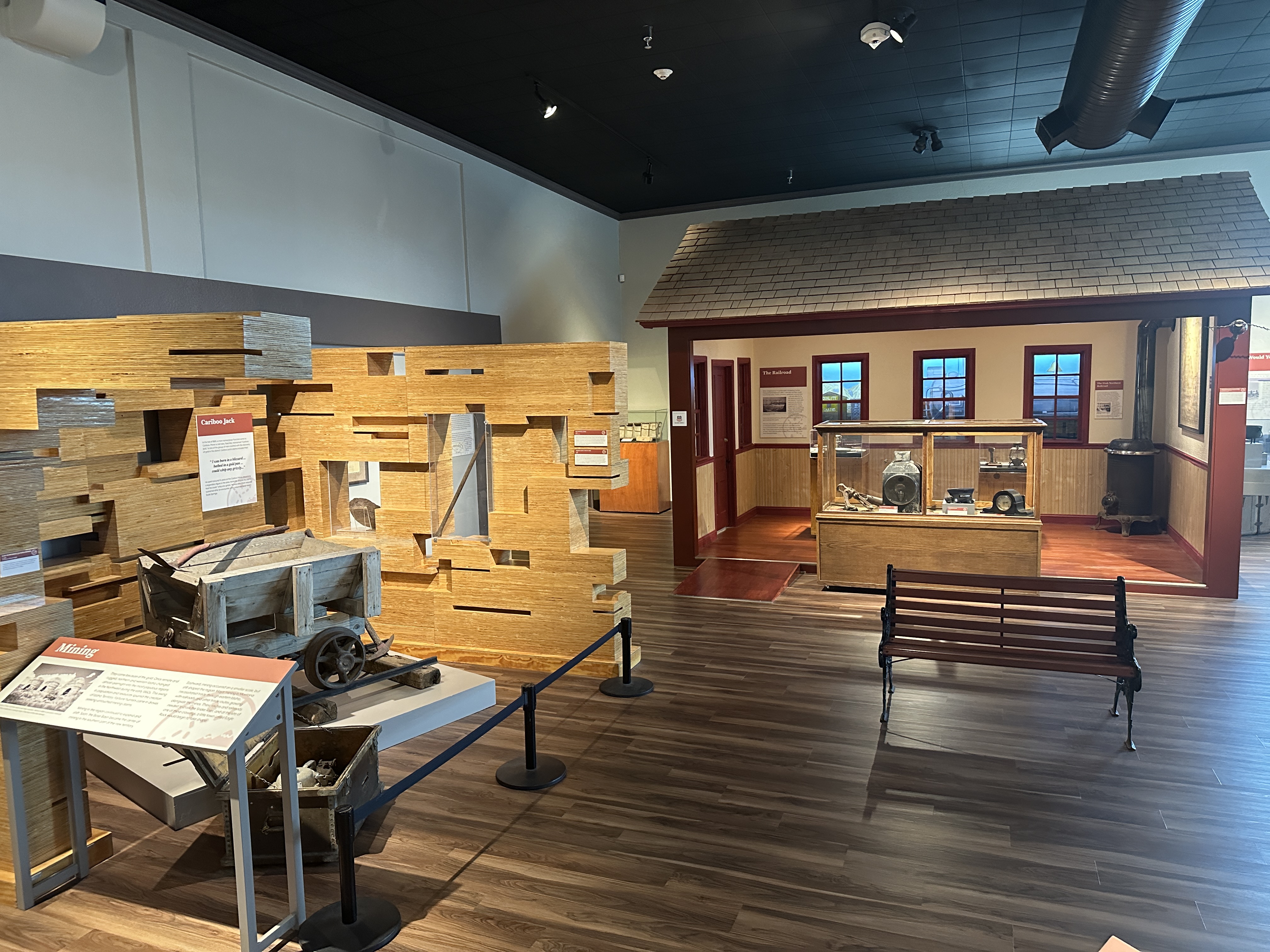
Prehistoric display
After my nap, I stopped by the Museum of Idaho. The museum has permanent and traveling displays. For some reason, the museum's website was down and I could not find out much about the museum. When I arrived I discovered that the entrance fee was $20. It seemed a bit steep, but I decided to check it out.
Pioneer display
The museum contained some permanent displays that chronicled the history of Idaho from prehistoric time, to the pioneer era, through development, and up to current times.
Industrial display
The railroad and mines shaped much of Idaho's development.
Side display
One fact that I found interesting was that during the late 1800s, the population of Idaho was only about 15,000 people. However, about one-third or 5,000 of the people were Chinese. The Chinese immigrants came to Idaho to work on the railroad and in the mines. After the turn of the century, there were exclusion policies at the national and state levels that prevented Chinese from settling in the US and in Idaho. So many of the Chinese moved back home, away from Idaho and to other states.
The South Fork of the Snake River
While I was in Idaho Falls, I stopped by an outdoor store called Idaho Mountain Trading. I struck up a conversation with one of the staff members named Brook. I mentioned that I was visiting Idaho with the hope of hiking and fly fishing, but that the hot temperatures and smoke from wildfires were not making it easy. She was very encouraging and shared that I should try to visit the famous South Fork of the Snake River and perhaps backpack the Palisades Creek Trail to the lower and upper lakes. The area is on the eastern border of Idaho and close to Grand Teton National Park. The temperatures were typically cooler in the area and it appeared that the smoke was not reaching the area.
So I traveled a few hours to the famous Snake River. The river was deep, wide and fast where I was located, it was late in the afternoon, I was tired from driving, so I didn't fish. I did had other plans.
Angler sign
I didn't fish the Snake River because the temperature was still too warm. When the temperature is too warm, the trout that are caught and released often struggle and do not survive.
Taking a lunch break on a rock to stare at the Lower Palisades Lake.
I decided to park my vehicle and set out on foot on a backpacking trip along the Palisades Creek Trail to Upper Palisades Lake. This was a nice hike that would start at about 5,500 feet above sea level and reach 6,800 feet over about 14 miles.
Upper Palisades Lake
By the early afternoon, I reached the Upper Palisades Lake. It was a beautiful alpine emerald colored lake. I set up my hammock, took an afternoon siesta, then went for a swim to bathe.
And I finally had the chance to fish.
Cutthroat trout
That afternoon, I caught and released three cutthroat trout and had strikes by several others. I did not have my net, so I simply made wet releases.
There was a group of teenagers across the lake. When they saw that I was catching fish, they walked over to the area where I was fishing. They politely inquired if they could fish, and I agreed. After they splashed the water, I didn't catch many fish. 😂 That's ok, sharing is caring.
This reprieve of hiking, swimming, camping and fishing really was a highlight of my time in Idaho. It was nice to be in cooler temperatures, sleep in my hammock and it was fun catching cutthroat trout.
Hail on the new vehicle 😬
I was feeling pretty good. I hiked down from the upper lake to the trailhead in one jaunt.
Just as I reached my car... it started to rain... then it started to hail. I was afraid that the hail would damage my new car, so I quickly relocated it under a nearby pine tree. Even though I wasn't completely shielded, the branches of the pine tree slowed down the hail enough that it did not dent my car. It was a close call.
I wondered what would have happened if I had started hiking down later, or hiked slower or taken a snack break. It was immaculate timing. I said a prayer of thanks.
Farmland
I hopped back onto the road and headed toward Central Idaho.
Mesa Falls Visitor Center
I stopped by Harriman State Park to check out Mesa Falls.
Mesa Falls, is a hidden gem of the Caribou-Targhee National Forest, a forest of over 6,200 square miles that extends to the parks of Grand Teton and Yellowstone. There are actually 2 waterfalls at Mesa Falls: the Upper Mesa Falls and the Lower Mesa Falls, and they can be reached via the Mesa Falls Scenic Byway. I stopped to check out both.
Driving into the dusk
As the sun began to set, I ventured down the highway toward my next stop. I arrived at my destination in the early evening and camped.
Craters of the Moon National Park
I wanted to explore the park in the coolness of the morning and before the sun heated up the black earth.
Cinder cone and cinder field
I woke up early in the morning and began to explore the park. I could tell that my body had finally adjusted to outdoor time.
This is a field of volcanic rock and cinder with a cinder cone in the background.
Dwarf buckwheat
This little tuff... it is a tiny cluster of dwarf buckwheat. It's leaves are attached to a root system that can be over three feet in diameter. The plants are regularly spaced out to efficiently tap available water.
Lava tube
This is a lava tube that was formed when a river of lava ran below the surface soil.
Indian Tunnel lava tube
This is a large lava tube and a tall slender shadow.
Photobombed
I hiked around the lava fields and through some lava tubes.
When I returned to my car, this Land Cruiser Overland Camper was set up to photobomb me. We were the only two vehicles in the parking lot.
Toyota Land Cruiser Overlander
Can you guess where they are from? There is a clue.
After exploring Craters of the Moon, I checked the wildfire and smoke forecast. It wasn't looking good. Much of Central and North Idaho were experiencing fires and smoke.
I decided that it was time to depart Idaho.
Ogden Historic District
Just a short drive south of Idaho is the town of Ogden, Utah. I've heard of Ogden but had never visited.
Horses in front of Union Station
The historic district had several restaurants, bars, tattoo parlors and shops. It wasn't what I expected. It wasn't bad, but it wasn't nice.
As I was walking down the street there were a number of people that appeared to be on drugs.
There were two teens on bicycles riding on the sidewalk behind me. I saw them out of the corner of my eye. As they approached me, I turned to look at them. One of the teens veered away, just barely missing me and started laughing. The sidewalk was over 10 feet wide. There was plenty of room to ride on the sidewalk or on the street. I think that he had intended to hit and run, but when I turned to look at him, I disrupted his plan. They rode away laughing.
Always maintain your situational awareness..
I stopped at a cafe to eat. I wanted to people watch so I took a seat at a table next to a window that overlooked the sidewalk. As I was eating, a man walked by on the sidewalk outside and waved at me. I waived back. Then he spun around, walked into the restaurant and stood next to me. The cafe staff saw this happen. He stood next to me for a while, just talking to himself. After a while, he started tallking to me and asked me for money. I said that I could not offer him money, but I offered him a muffin. He hung out for a while, then started talking to a girl next to me. After a while, we were all informed that the cafe was closing and we were kindly given the boot.
Ogden was not the town that I was expecting it to be. Sometimes you don't know until you go.
Utah highway
I didn't know where I wanted to go next, but I knew that I didn't want to stay around Ogden. I headed south. I looked online to see what was in the vicinity and saw Grand Junction, Colorado.
As I crossed the border between Utah and Colorado, I saw a Colorado Visitor Center. I love Visitor Centers because they offer free maps, free brochures, free coffee and free information about things to do. I noticed that now many of the visitor centers that I visited on this trip did ask for donations for coffee. Typically they are staffed by very friendly local people too. I've found that local knowledge always trumps the internet, people are awesome. During my stop at the visitor center, I shared the general direction that I was driving and asked for suggestions. The staff member encouraged me to check out Colorado National Monument, Mesa Verde and perhaps some hot springs around Durango. Say no more.
Colorado National Monument
After a short drive, I arrived at Colorado National Monument. Honestly, I had never heard of this Naional Park. The Visitor Center staff member described it as Colorado's Bryce Canyon. Let's see.
Overlook of Monument Canyon
I put on my hiking gear and set out. I hiked along the rim of a canyon and I was pretty impressed with Wedding Canyon and the red rock monoliths such as Independence Monument, Kissing Couple and Pipe Organ.
Rock formation
Here's a little clip from the park's website about the rock formation in Colorado National Monument.
Seeking shade
It was still warm, so I took shelter in the shade of the red rock formations for breaks.
Red Rock Alcove
During the heat of the afternoon, I hiked in the canyons, walking in the shade of the canyon walls.
I found this small canyon that led to this alcove.
Ranger Talk
In the early evening, I sat in on a Ranger Talk. Unfortunately, there was a thunder and lightning storm brewing on the horizon. When some thunder and lightning struck nearby, the Ranger called off the talk and we all headed for our camps. I was planning to hike into the canyon and camp, but due to the severity of the lightning storm I elected to camp in my vehicle. I think that it was a wise decision.
The Devil's Kitchen
The next day it was cooler and calmer. I drove then hiked to an area called the Devil's Kitchen.
Looking around the Devil's Kitchen
I looked around the Devil's Kitchen, but I could not find the Devil nor anything that he may have been cooking.
Window with a view
Inside the heart of the Devil's Kitchen, I did find this window with a view that had an outstanding overlook of the surrounding valley. In the distance, I could see Grand Junction, Colorado.
Ouray
Afer spending a day and a half at Colorado National Monument, I passed through Grand Junction but moved south until I came to the town of Ouray, Colorado.
This is another mountain town of which I've heard, but have never visited. I was amazed by the number of tourists and especially the amount of adventure sport tourists. There were groups of 4x4 enthusiasts, adventure motorcyclists, mountain bike riders, hikers/backpackers, and of course many people enjoying the hotspring resort and spa. I saw several establishments promoting Via Ferrata Tours. I didn't have time for a tour, but I need to return someday soon to climb a Via Ferrata.
Main Street
I walked up and down the Main Street,
Buff Buffalo
Caught sight of this shiny Buffalo.
Dino
Found this dinosaur skeleton riding a mountain bike.
BLM camping
I drove about 15 minutes outside of town, up a dirt road and found this nook of a campsite.
Doesn't my 4Runner look perfectly situated in its natural habitat?
Hammock time
The weather was nice and cool, so I decided that it might be nice to hammock camp.
It was a perfect night. I sometimes sleep in my hammock without a tarp. It was a clear evening, but my intuition told me to set up my tarp. Fortunately, my intuition led me to a good decision. In the middle of the night, I was treated to a gentle rainstorm. Nothing is better than the pitter-patter sound of rain hitting a tarp while being safe and sound cuddled up in a hammock.
4x4 trail book
The next morning, I packed up and went back into Ouray and stopped by the Visitor Center.
I inquired about a 4x4 trail that the man at the previous visitor center mentioned to me called the Ophir Pass Trail. He said that it was one of the most scenic trails in Colorado and manageable with my new 4Runner. The lady at the Ouray Visitor Center said that as long as it was not raining, it would be a nice trail to travel. She even offered up a 4x4 trail book and allowed me to take a photo of the trail map for the Ophir Pass Trail. It looked good.
Off to the Ophir Pass
I filled up with gas and made my way to the trailhead.
Views for miles
The trail started off as a gravel road with a gentle rise. I was impressed by the views
Views in front and behind
The farther I drove, the more I became impressed with the views - both those in front of me and those behind me.
Crossed paths with my friend
Along the trail, I happened to run into a friend of mine Brian. We were heading in the opposite directions, but his rig is easy to recognize. He was overlanding around the area with a group of his friends for the week. His 4Runner is pretty built up and it stands out. Mine looks like a noob.
What goes up, must come down
Regardless, my stock 4Runner handled the trail easily. There were some exposed slopes, shale slides, ruts and steep descents. I just engaged 4WD low, took my time and managed my way through it.
Inclined
This was not an exaggerated camera angle, this was the actual trail angle, I was holding the camera level within my vehicle.
I think that it took me about 1 1/2 hours to complete the 10 mile trail.
Telluride Main Street
I came out on the far side of the Ophir Pass Trail and realized that I was close to the town of Telluride. So I took a little detour to visit the town.
Telluride house
In many ways, Telluride is a typical Colorado mountain town. However, I did notice that there were some really well-kept houses right on Main Street.
Lunch
I didn't have an objective for stopping in Telluride. It was lunchtime, so I stopped by a grocery store, picked up a Ceasar salad, some macaroni salad, and orange juice, found a local park, and had a little picnic.
The reality is that during this trip, I was eating mostly outdoors, so almost every meal was a picnic.
City Park
After finishing my lunch at the park, I noticed a community pool with showers nearby. Gathering my toiletries and clean clothes, I bought a few tokens and took a refreshing shower.
Feeling energized, I decided to continue my journey. Without a specific destination in mind, I remembered that the staff at the Visitor Center recommended that I visit Mesa Verde. Checking Google Maps, I saw it was nearby and adjusted my route accordingly.
On top of the mesa
After a half day of driving, I arrived at Mesa Verde National Park. Fortunately, I found an available campsite and settled in for the night.
Intending to explore the park more fully early the next morning, I turned in to sleep.
Mesa Verde Cliff Palace
My decision to visit Mesa Verde turned out to be a great choice. I woke up early and drove directly to the farthest point of interest - the Cliff Palace.
I often use this strategy in popular national parks… drive to the farthest point of interest without stopping, then explore the other sights on the way back. I passed numerous scenic overlooks and points of interest, knowing that I could see them on my return trip.
By following this plan, I enjoyed the most important sights without interruptions, avoided the crowds, and still had plenty of time to explore the remainder of the park at a leisurely pace.
The Cliff Palace is probably the most recognized sight in the park. It contains 150 rooms and 23 kivas and housed a population of approximately 100 people. The park signage and Rangers often mentioned that all of the sites are not abandoned relics, but are still inhabited by the spirit of the people who have lived there.
Kiva
It is thought that the Cliff Palace and structures like this Kiva were a social and administrative site with high ceremonial usage.
Park Point
I sought out and hiked to the highest point in the park at 8600ft, a place called Park Point. Looking west I could see the Four Corners - where the states of Arizona, Colorado, New Mexico and Utah share a border.
Durango
After spending the day visiting Mesa Verde, I drove to the town of Durango. It's another mountain town that I've always heard of, but never visited.
Chicken Curry
As it was becoming my new habit, I took a stroll along Main Street. I passed by a Chinese restaurant called May Palace. I hadn’t eaten Asian food for a couple of weeks and was craving some. I ordered some curry chicken and to my surprise, it was really good. The owner stopped by my table to chat. It turns out that she previously lived in Texas and attended the University of Texas. We chatted for a while. She said that shortly after college she visited Durango and never left.
False Hot Springs
After a solid meal, I felt like exploring he surrounding area. I did a little online research and discovered that there was a hot spring somewhat nearby called the Piedra River Hot Spring. It was a natural and free hot spring located up a dirt road and down a dirt path.
I read the directions about how to find the hot springs but did not save the information to my mobile. Supposedly it was 10 miles up a dirt road. Then a 1.5 mile hike down a ravine. I drove to the Piedra River and found the road. It was getting late, so I pulled over and camped.
The next morning, I got an early start. I drove down the dirt road for about 10 miles. I found the trail and started to walk. I wasn't keeping track of my mileage very closely. I walked and walked. I saw one area with circles of rocks that looked like hot springs, but it turned out to be false hot springs. I explored up and down the river for a while and was getting a little frustrated. I decided to turn around and try to find someone who might be hiking to the hot springs.
I walked no more than 1/4 mile and encountered a guy walking in my direction. We stopped and greeted each other. He asked if I had come from the hot springs. I shared that I could not find them. I asked if he would mind showing them to me. He said sure. And so we ventured on.
Piedra River Hot Spring
We hiked no more that 1/4 mile, arived a meadow and just below the meadow within the Piedra River, there were the hot springs. I had missed the location because I failed to walk about 200 yards.
The Real Piedra River Hot Springs
I finally found the Piedra River Hot Springs and relaxed. There were several pools with varying temperatures. I found a pool that was about 102 and began to soak. The guy that directed me to the hot springs chose another pool and began to soak. We chatted while we basked in the hot springs and listened to the gurgling sound of the water running down the river. His name was Jason Thies. He's a local from Durango who visits the hot springs regularly. He shared that he is also a singer-songwriter who plays local gigs, tours occasionally, and has cut a few albums. You can listen to his music on various streaming services. We talked about the music scene in Austin. He said that back in the day he lived in Austin and played music there. We discussed how the town has changed. We chatted about different neighborhoods. It turns out that we lived in the same apartment complex, but at different times, on South Lamar near the Broken Spoke Honky Tonk. It is funny how we sometimes find connections in such unusual situations.

Siesta
I only planned to spend 1 or 2 hours at the hot springs. I think I ended up spending 3 or 4 hours. I lost track of time. Soaking in a hot spring makes me a little sleepy, so I hung up my hammock, ate lunch, and took a nap. When I felt rejuvenated, I hiked out of the ravine back to my vehicle.
Pagosa Spring Resort
About 40 minutes down the road was the town of Pagosa Springs. The town is noted for having several hot springs and one really huge hot spring resort called The Springs Resort. I didn't bother checking into the resort, because I knew about another option.
The San Juan River
Along the San Juan River, up the river and on the opposite bank, there is another free hot springs where many of the locals soak.

Nathan's Hippy Dippy Hot Springs
Can you guess which hot spring I chose?
I elected to soak in Nathan's Hippy Dippy Hot Springs.
Cooling off in the San Juan River
One of the great aspects of Nathan's Hippy Dippy Hot Springs is that one can soak in the hot water, and then when one wants to cool off, one can jump into the cool river. There's no shade so I elected to wear my sun hoodie.
An Ode to Trout
After soaking in the hot springs and cooling off in the river, I went for a walk around Pagosa Springs. I stumbled across this sculpture park.
Camping at a Fire Watch Tower
As the afternoon stretched into the evening, I started to look for a place to camp. I did some research online and found a parcel of BLM land. One note said that there was an old decommissioned fire watchtower at the end of a dirt road and on the top of the mountain. It took some searching and some getting lost, but I eventually found the fire watch tower just as the sun was setting. My timing couldn't have been more perfect.
Sunset
Just watching the sun fade away.
No time to look back, keep moving forward
I slept really soundly because this BLM land was so isolated and quiet. The next morning I got up early and started driving toward Santa Fe, New Mexico.
Santa Fe Farmers Market
I've visited Santa Fe, New Mexico a few times. There is a lovely downtown area. There is also a pretty great Farmers Market near the Railyard.
Fresh veggies
I walked around a bit to check out the local offerings.
Hot chilis
I wasn't really in the mood for shopping, but I was hungry.
El Chile Toreado
I heard about this great tacqueria food truck called El Chile Toreado and decided to check it out.
Quatro tacos por favor
I ordered 2 pork tacos adobada and 2 chicken tacos con limon. The condiments of pickled onions, pico de gallo and salsa were in self-service containers, I may have overdone it. The food was delicious.
Another day, another drive
I continued to make my way south and east.
I love desert landscapes and big sky.

Find My iWatch... Oops!
It was about this time that I noticed that I had not seen my iWatch for a while. Sometimes I take it off to charge it in my center console. Sometimes I take it off just for comfort and place it in my luggage. I hadn't seen it in a while, so I decided to use the Find My iWatch function on my iPhone to see where it might be located within my vehicle. The Find My iWatch feature indicated that the last known whereabouts were back at the fire watchtower near Pagosa Springs. This was some 300 miles back and half a day of driving.
Did it fall off my wrist? Did I accidentally let it fall out of my vehicle? At that campsite, I had arrived late in the evening and departed early in the morning when it was semi-dark. Oops!
I decided that I couldn't look back, I had to move forward.
Sunset over Sand
After a full day of driving, I found myself at my next stop White Sands National Park in New Mexico. I arrived just as the sun was setting.
NPS App Audio Tours
When I arrived, the Visitor Center was already closed. However, I used the Visitor Center WiFi and NPS App to download the free audio self-guided tour of the park. The audio tours were great.
Moonrise over Mounds
The moonrise over the sand mounds was pretty nice too.
Cloudcroft, New Mexico Post Office
The next stop was Cloudcroft, New Mexico.
Mexican Canyon Trestle Bridge
Just outside of Cloudcroft is the Mexican Canyon Trestle. It is a historic wooden trestle bridge nestled within the Sacramento Mountains. It is a multi-tier wood-frame trestle that was part of the Alamogordo & Sacramento Mountains Railroad, a railroad that operated from 1899 to 1947. The railroad had about 26 miles (42 km) of track connecting Alamogordo, New Mexico to spruce and fir timber areas within the Sacramento Mountains.
Main Street
The Main Street and Downtown is set up like an old western town.
A morning hike
In the morning, I found a trail in the Lincoln National Foret and went for a hike.
I love it when there is dew on the ground and the sun is low on the horizon.
Low sun, long legs
It makes great shadows.
Seeing the forest and the trees
Forest for miles.
Balmorhea State Park Spring Swimming Pool
After spending some time exploring Cloudcroft, New Mexico, I journeyed east. After crossing into Texas, the roads were straight, flat and occupied by lots of tracker trailer trucks transporting goods and oil to and from the oil fields of West Texas. It wasn't pleasant driving.
I eventually reached an oasis in the desert of West Texas called Balmorhea State Park. I've visited this park various times. Even when I'm not planning to stay at the park, I often stop by to go for a swim and cool off. The park has a natural spring-fed swimming pool that stays between 72 to 76 degrees Fahrenheit. I went for a swim and it felt amazing. The swimming pool facility also has a shower to clean up after swimming.
Davis Mountains State Park
From Balmorhea, I drove a short distance to Davis Mountains State Park. I've visited this park various times as well. The park is in the mountains and the temperatures are often 15 to 20 degrees cooler than the temperatures of the surrounding desert floor.
Another day, another sunset
After checking in at the park kiosk, I drove up Skyline Drive Road to a hill that has a scenic overlook. I wanted to watch the sunset. The sunset was obscured by the clouds, but it was still nice. In the lower left corner of this image is the India Lodge. It is undergoing remodeling, but hopefully will be completed later this year.
A little looking back
I looked in my rearview mirror and saw this awesome moon rising scene.
Catching the sunset and the moon rise
So I turned around and watched the moon rise over the West Texas high desert. The colors!

An early morning start
The next day would be a long day of driving across Texas. I woke with the sunrise and headed east. After 7 hours of driving, I would arrive home.
Bringing Back the Blue Ox
It was an awesome summer and an excellent adventure!
I had the opportunity to travel around Idaho and get a feeling for the people, culture, natural beauty, hiking and fishing.
I had the chance to visit many new places in Utah, Colorado and New Mexico.
I picked up a new adventure vehicle... I brought back the Blue Ox.
Over the next few days, I hope to post some videos and stories on my YouTube channel and Instagram. Follow along if you'd like.
The End